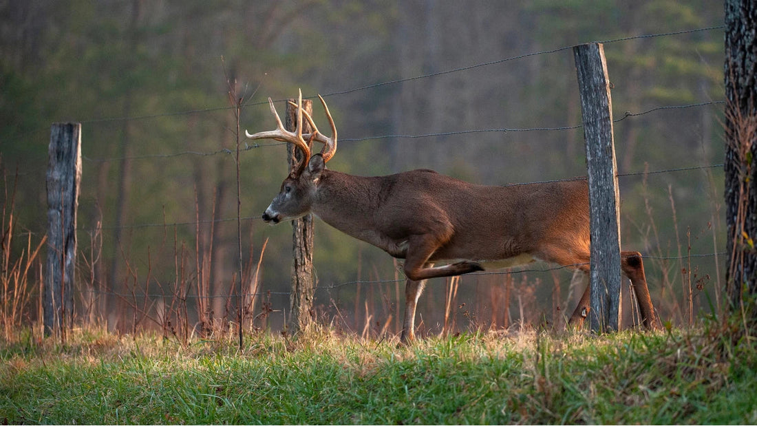
With deer season coming up soon, we are getting ready to go back into the woods and hunt. Getting out there with new gear and a fresh mindset is exciting, but sometimes we need a little guidance on the newest regulations to stay safe and legal. We have compiled the best up to date info just for our Thermal Hunting community.
Remember, hunting deer with a thermal scope is illegal in Alabama. Alabama law prohibits the possession of any equipment that uses electronics to increase the ability to see in the dark (night vision/thermal equipment) while hunting deer. While a specific license allows nighttime hunting of feral swine and coyotes with thermal equipment during established seasons, this exception does not extend to deer.
Deer Season 2025-2026
ANTLERED BUCKS are defined as those male deer with one or more antlers visible above the natural hairline.
UNANTLERED DEER are defined as all deer without one or more antlers visible above the natural hairline
White-Tailed Antlered Buck Limit
- Three per hunter during all combined seasons, one per day. One of the three must have at least 4 antler points 1 inch or longer on one antler (except for Barbour County). A point is defined as an antler projection of at least one inch in length from base to tip. The main beam tip shall be counted as a point regardless of length.
EXCEPTIONS: 1.) BARBOUR COUNTY ANTLER RESTRICTION – white-tailed deer antlered bucks must have a minimum of three points on one side, (except on the statewide special youth deer hunting dates during which any antlered buck may be taken). 2.) WILDLIFE MANAGEMENT AREA (WMA) BONUS BUCK – One per hunter during all combined bonus buck hunt dates will be allowed to be harvested from a selected collection of WMA’s on specific hunt dates depicted on the WMA map permits that will not count towards the hunter's State three buck limit. Must be validated at the WMA check station by WFF personnel.
White-Tailed Unantlered Deer Limit
-
During the Unantlered Deer Gun, Special Muzzleloader, Bow and Arrow and Special Youth (under 16) Seasons, in Zones A, B, D, E & CMZ two unantlered deer or one unantlered deer and one antlered buck may be taken per day. In Zone C one unantlered deer and one antlered buck may be taken per day. See Special Exceptions below for selected areas.
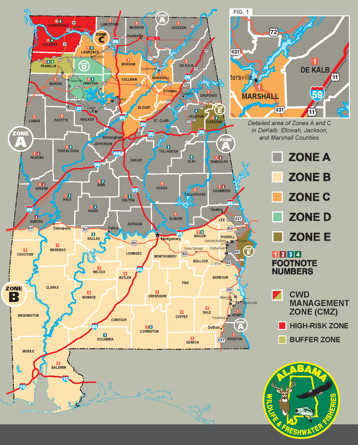
2025-2026 Deer Zone Map
SPECIAL EXCEPTIONS –
Dog Deer Hunting:
- Dog Deer Hunting Prohibited Except by Special Permit from the Department: BALDWIN; CHAMBERS; CHOCTAW (that area south of AL Hwy. 10 and west of AL Hwy. 17 and north of County Road 18 from AL Hwy. 17 to County Road 14 then north of County Road 14 to the Mississippi state line); COLBERT (that area west of US Hwy. 43); COOSA; COVINGTON (north of US Hwy. 84); ELMORE (that area inside the following boundaries: from the Coosa County/Elmore County line at the east bank of Lake Jordan, to AL Hwy. 9, south along AL Hwy. 9 to the intersection of US Hwy. 231, south along US Hwy. 231 to the intersection of AL Hwy. 14, west along AL Hwy. 14 to the east bank of the Coosa River, north along the east bank of the Coosa River to Lake Jordan, back to the Coosa County/Elmore County line); GENEVA; HENRY; MACON (that area inside the following boundaries: from County Road 24 at the Lee County line, west and south to County Road 26, west to County Road 10, southeast to County Road 5, south to County Road 47, south to County Road 2, east to the Russell County line); MARENGO; MONROE; PICKENS (north of US Hwy. 82); TALLAPOOSA; and WILCOX counties. Individual property owners in CHAMBERS and COOSA counties may hunt with dogs on their own property without special permit. No dog deer hunting allowed on Open Permit-Public Land (see 220-2-.85).
- By Stalk Hunting Only (No Dogs): BIBB; PERRY: (that area inside the following boundaries: east of AL Hwy. 219, south of US Hwy. 82 and north of AL Hwy. 183); BUTLER (that area south of AL Hwy. 106 and east of I-65); CHEROKEE; CHILTON; CLEBURNE; COFFEE (that area inside the following boundaries: AL Hwy. 134 from the Covington County Line, east to County Road 460, south to the Geneva County line, east to the Dale County line, north to AL Hwy. 134, west to AL Hwy. 87, north to US Hwy. 84, west to AL Hwy. 189, south to AL Hwy. 141, north to US Hwy. 84, west to the Covington County line); CRENSHAW (north of AL Hwy. 10 and that area inside the following boundaries: from the east city limit of Luverne, US Hwy. 29 east to the junction of County Road 57, County Road 57 south to the junction of Davis Road, Davis Road west to County Road 41, County Road 41 south to US Hwy. 331, US Hwy. 331 north to County Road 41, County Road 41 north to County Road 39, County Road 39 north to the Luverne city limit); DALE (that area inside the following boundaries: Judy Creek south to Dale County Road 36, east to AL Hwy. 27, north to the Henry County line, north to the Barbour County line, west to Judy Creek); DEKALB; ELMORE (that area inside the following boundaries: east of US Hwy. 231, south of AL Hwy. 14, west of Tumkeehatchee Creek and north of the Tallapoosa River); FAYETTE (that area inside the following boundaries: west of US Hwy 43 and north of AL Hwy. 18); FRANKLIN; HALE and PERRY: (that area inside the following boundaries: from Hale County Road 32 at the Hale County Line, west to the intersection of AL Hwy. 25, AL Hwy. 25 north until it intersects with the Talladega National Forest boundary, following the boundary south until it intersects the Perry County line, following the National Forest boundary east to Perry County Road 23, south to the intersection of Perry County Road 29, south to the Spring Hill Church Road, Spring Hill Church Road west to the junction of Perry County Road 23 and AL Hwy. 14, west to the Hale County line); GREENE; PICKENS and TUSCALOOSA: (that area inside the following boundaries: in Pickens County from the intersection of US Hwy. 82 and County Road 63, south on County Road 63 to Benevola, County Road 2 (commonly known as the Romulus Road) east through Greene County to US Hwy. 82 in Tuscaloosa County); HOUSTON; JACKSON; LAMAR; LAUDERDALE; LAWRENCE; LIMESTONE; MADISON; MARION; MARSHALL; MORGAN; RANDOLPH; TUSCALOOSA (that area north of US Hwy. 82); and WINSTON (that area east of AL Hwy. 5 from the Walker County line to Natural Bridge and all that area north of US Hwy. 278).
U.S. Corp Of Engineers Lands:
On U.S. Army Corp of Engineers (USACE) Lands in Alabama, the special muzzleloader, air rifle, and unantlered deer seasons are allowed the same as privately owned or leased lands in those counties, if USACE does not further restrict. Be aware to consult USACE regulations regarding hunting activities and boat ramp use prior to hunting USACE regulated areas. Special Permits from the USACE may be required and some USACE areas are closed to hunting. For complete information concerning hunting on USACE lands, visit the USACE Mobile District website at the following: https://www.sam.usace.army.mil/Missions/Civil-Works/Recreation/Hunting/.
U. S. Forest Service (USFS):
- STALK HUNTING – No Dogs (same season dates as open permit for county) except Wildlife Management Areas – one deer per day.
- DOG DEER HUNTING – No Dogs, except for USFS Lands within Calhoun, Clay, and Talladega counties during the Dog Deer Season on open permit-public lands – on Thursdays and Fridays until 2:00 p.m.; on weekends during legal shooting hours. No dog deer hunting on Monday, Tuesday, or Wednesday of each week unless Christmas Day or New Year’s Day falls on a Monday, Tuesday, or Wednesday. No other state or federal holidays are included in this exception. One deer per day.
- NO DOG DEER HUNTING ON THE PINEY WOODS/IVORY MOUNTAIN AREA – The borders of which are defined as follows: bounded by the Cleburne County line to the north running east and west, then to the west by Clay County Road 3 running south to State Route 49; The south border is Clay County Road 66 running east and west from State Route 49 to Hwy 9; The eastern border is Hwy 9 running north from Clay County Road 66 to the Cleburne County line.
- Abandonment of any personal property on National Forest Service Lands (tree stands, hunting blinds, hunting equipment, pets, livestock, pen-raised quail, or other animals) is PROHIBITED. The prohibition (CFR 36. II. 261.10 e) will be enforced by USDA law enforcement personnel.
- Chronic Wasting Disease Management Zone (CMZ): During Deer Gun Season on privately owned or leased land only, two unantlered deer may be taken per day. This does not apply to Wildlife Management Areas, Community Hunting Areas, and open permit public lands located within the CMZ.
SPECIAL YOUTH (under 16) DEER HUNTING Statewide, (includes all Privately Owned, Leased Lands and Open Permit – Public Lands (except Wildlife Management Areas). The same legal arms and ammunition apply as in Deer season, in accordance with Rule 220-2-.119
ADDITIONAL ZONE MAPS
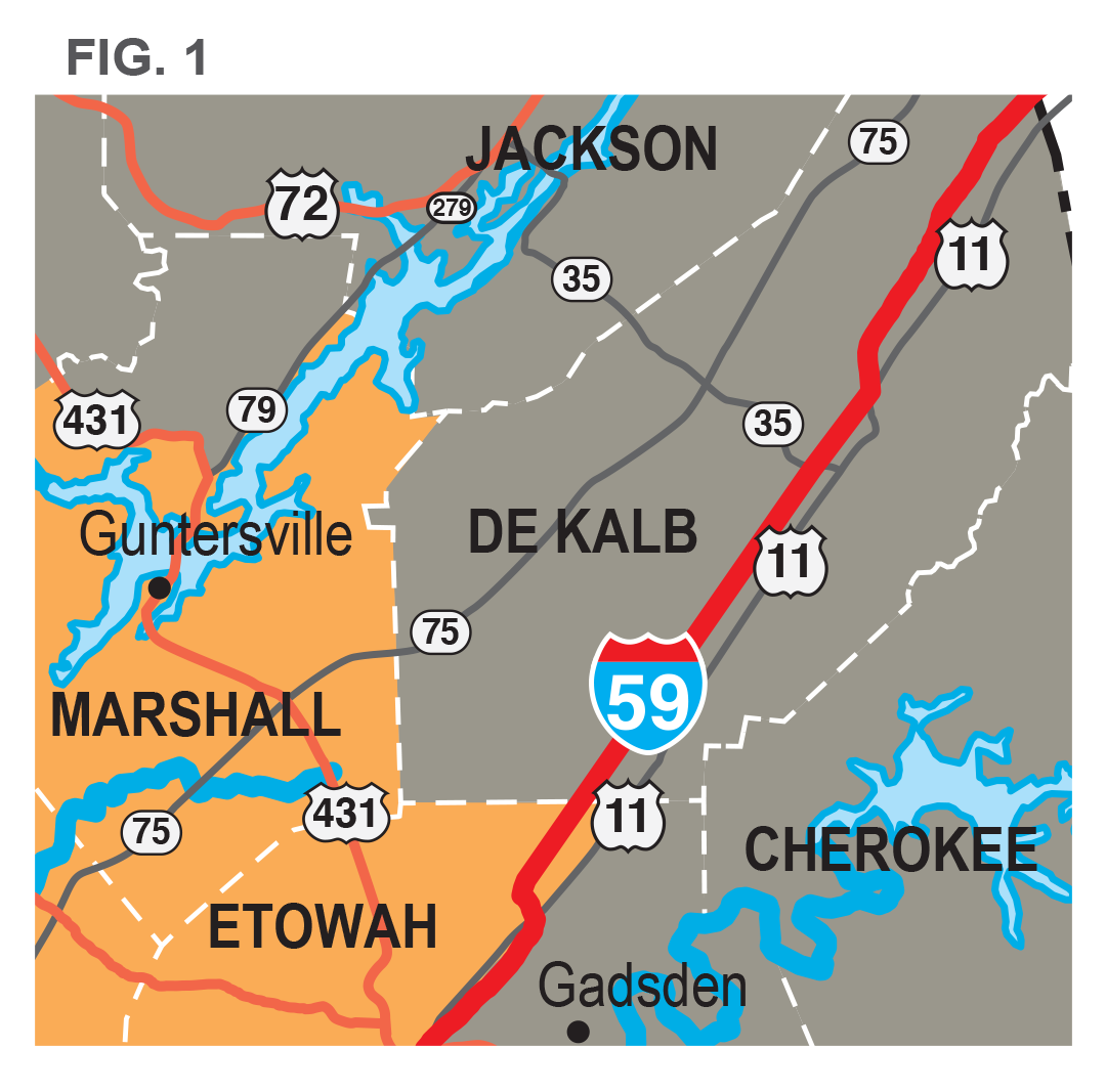
Detailed area of Zone A and C in DeKalb, Etowah, and Jackson, and Marshall Counties.

Zone B Eastern Boarder Detailed Map.
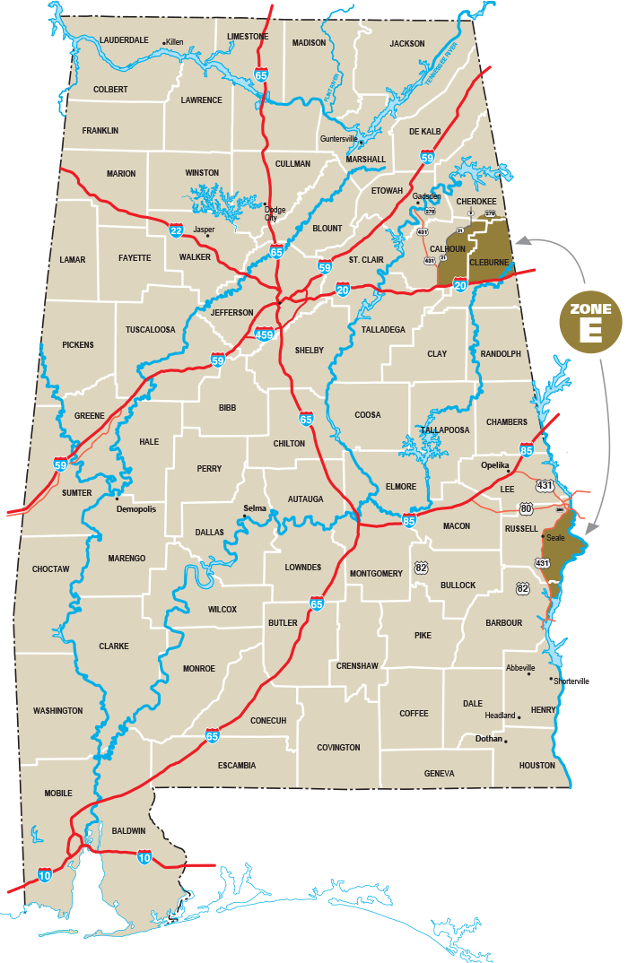
Zone E is in two locations in East Alabama.